Airborne Research Australia
Not-for-Profit Independent Approved Research Institute

All Donations are tax-deductible.
We thank you for your consideration.
25m to 7km altitude
up to 7 hours
and 1000km
multi-sensor
multi-platform
focus on science applications
collaborating and sharing
AIRBORNE
Remote Sensing
Bathymetric and topographic LiDAR
(532, 1064, 1550nm)
VNIR/SWIR hyperspectral
(400-2500nm)
Hi-res spectral
Thermal IR
Microwave
(active, passive, InSAR, L-,P-,Ka, Ku)
Aerial Photography
and Video
Flying for science ... not for profit
... probing the environment using the least intrusive and
cost-efficient state-of-the-art airborne technologies ...


AIRBORNE
In-Situ
Meteorological
(wind, turbulence, air temperature, humidity,
eddy fluxes, ...)
Particles
(fine, ultra-fine,
sampling, ..)
Trace Gases
(CO2, CH4, NH3, ...)
Aerosols
Multi-platform
UAV-sensors
Third Party Sensors
QuickLinks
Presentations
Publications
Image Gallery
Videos
Instrumentation
Airborne Platforms
Unrestricted research flight operations Australia-wide - day and night - over water and land.
We understand your research requirements, because we are scientists ourselves.
Browse our projects to see our expertise
and see the Earth and our Environment as you have never seen it before
Or click here to see -
-
Who we are
-
What we do, and
-
How we do it
Data from many of our projects is available for download on request:
Most/all ARA data available ARA data may be available Data not or not yet available

Methane Emissions from LNG facilities in
Australia
2023-2024

Methane Emissions from LNG facilities in
Australia
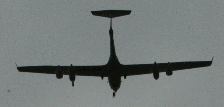
Airborne measurements of the concentration of methane and carbondioxide are made at the eight largest LNG-facilities in Australia - the Karratha Gas Plant and Pluto near Karratha/WA, Whetstone near Onslow/WA, Gorgon on Barrow Island/WA, Ichthys near Darwin/NT and the three facilities on Curtis Island near Gladstone/Qld. The key scientific tool of this international study is one of the ARA research motorgliders instrumented with a Los Gatos UGG gas analyser together with atmospheric sensors.
Funded by the UN Environment Programme, International Methane Emissions Observatory (IMEO)
GasAnalyser, Meteo, Bags, RGB, Lidar, Video

Methane Emissions from Surface and Underground Coal Mines in the Bowen Basin, Qld
2023
Methane Emissions from Surface and Underground Coal Mines in the Bowen Basin, Qld
In a collaborative project between the University of Bremen/Germany (UB) and ARA, airborne measurements of the concentration of methane and carbondioxide are made over surface and underground coal mines in the Bowen Basin in Queensland/Australia The key scientific tools of this international study are two sets of sensors flown in the two ARA research motorgliders, the M2DL spectrometer from UB, and a Los Gatos UGG gas analyser together with atmospheric sensors, respectively.
Funded by the UN Environment Programme
International Methane Emissions Observatory (IMEO
GasAnalyser, Meteo, Bags, M2DL, Lidar, RGB, Video

Bushfires
Cudlee Creek &
Kangaroo Island, SA
2019-20
Bushfires in the Adelaide Hills and Kangaroo Island
In late Dec 2019 and Jan 2020, large bushfires devastated areas in the Adelaide Hills and on Kangaroo Island in South Australia. To assist in the recovery process, we are mapping specific areas using high resolution LiDAR, VNIR hyperspectral scanning and high resolution RGB imaging.
Data from the flights is available for download.
Funded by the Hackett Foundation and ARA
Lidar, Hyperspectral, RGB

Methane Emissions from CSG operations,
Surat Basin, Qld
2018-20
Airborne Measurements for Estimating Methane Emissions in the Surat Basin, Qld, Australia
One of the key tools of this international study are the airborne measurements using the ARA research motorglider instrumented with a Los Gatos UGG methane gas analyser together with atmospheric sensors. UNSW and MetAir in Switzerland are partners in this project.
Funded by the UN Environment Programme
GasAnalyser, Meteo, Bags, RGB

Deep History of Sea Country,
Dampier Archipelago, WA
2017-19
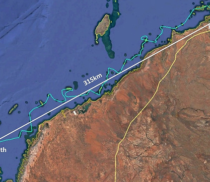
Deep History of Sea Country
This is a pioneering, multi-disciplinary study of submerged landscape archaeology in Australia designed to investigate the records of the now-submerged Pilbara coast (spanning 50,000 to 7000 years ago). Information from drowned contexts will help address critical debates in Australian prehistory relating to past sea-level rise, population resilience, mobility and diet.
ARC Discovery Project
Bathy- and Topo-Lidar, RGB

Iron Range Rainforest
Cape York,Qld
2018-19
Iron Range Rainforest, Cape York
Recently, the Iron Range Research Station (IRRS) in collaboration with Airborne Research Australia (ARA) gathered airborne lidar data of the largest contiguous block of lowland rainforest remaining in Australia.
Funded by the MAXIM Foundation and ARA
Lidar, Hyperspectral, RGB

Construction of
the Northern Connector,
Adelaide, SA
2016-19
Changing Landscapes
Northern Connector
Construction of a new 4-lane expressway through areas of mangroves, saline ponds, saline creeks and former market gardens North of Adelaide
Lidar, RGB
Pilbara Islands, WA
2016-18
Airborne LiDAR of 35 of the more than
150 small islands along the Pilbara Coast
Western Australia
Studying the effects future cyclones may have
on the shape of these islands.
Bathy- and Topo-Lidar, RGB

Walking with
Dinosaurs,
Broome, WA
2014-16
Walking with Dinosaurs
The coastline of the Dampier Peninsula, Western Australia, is one the largest stretches of dinosaur track-sites in the world. The aim of this project is to map the tracksites utilising aerial photography with both manned and unmanned aircraft, airborne and hand-held LiDAR imaging, and digital photogrammetry.
ARC Discovery Project
Topo-Lidar, RGB, Video

Bathymetric Lidar Trials, Adelaide, SA
2016
Bathymetric Lidar Toolkit
Description and Brochure
Funded by ARA
Bathy-Lidar

Airborne Lidar of Evaporation Ponds,
Adelaide, SA
2014-16
Airborne Lidar of Evaporation Ponds
near St. Kilda
South Australia
Bathy-Lidar, Topo-Lidar, RGB

Mangrove Dieback
Gulf of Carpentaria, Qld
2017
Mangrove Dieback
Gulf of Carpentaria
The project’s purpose was to map the sudden and widespread dieback of the mangrove forests along the coast. ARA mapped more than 3,000km of coastline around the Gulf of Carpentaria using airborne LiDAR and RGB-imagery.
Topo-Lidar, RGB

Ultrafine Particles from
Coal-Fired Powerstations in Qld
2014-19
Ultrafine Particles
from Coal-fired Powerstations
The study indicates modern coal-fired power stations equipped with flue gas cleaning and NOx reduction are the biggest individual sources of ultrafine particles (UFP) and can have considerable impacts on climate in several ways.
UFP, Meteo

Have a guess where this is
?

Nullarbor Cliffs, SA & WA
2016
Nullarbor Cliffs
During a ferry flight from Adelaide to NW-Western Australia, a Riegl VUX-1UAV was tested flying along the near-vertical cliffs of the Nullarbor Coast - the "Edge of Australia".
"We actually flew about 170km(!) along the cliffs, from the Head of the Great Australian Bight to close to Eucla.
Funded by ARA
Topo-Lidar, Video

Saline Pond XB8A,
Adelaide, SA
2016
Changing Landscapes
Pond XB8A
The coastal landscape to the North of Adelaide where a vast area of no longer used industrial salt producing evaporation ponds is being converted into a variety of other landscapes, such as conservation parks, wildlife refugees (especially for birds) and also for the development of alternative industrial uses.
Funded by DEW and ARA
Topo-Lidar, Hyperspectral, RGB

Greenhouse Emissions
from Cattle Feedlot,
Charlton, Vic
2015
Greenhouse Gas Emissions from Cattle Feedlot
Greenhouse Gas Emissions from a 17,000+ cattle feedlot near Charlton, VIC. using airborne technologies
GasAnalyser, Meteo, Bags, RGB, Video

Lidar Bathymetry
of Ningaloo Reef, WA
2016
Lidar Bathymetry of Ningaloo Reef
Ningaloo Reef is one of the most pristine coastal areas in Australia. We flew our two Riegl Lidars over the Tantabiddy Section of the reef to derive the structure of the seafloor. The results are nothing short of spectacular.
Bathy-Lidar, Topo-Lidar, RGB

Pinery Bushfire, SA
2015
Pinery Fire in SA
In late November 2015, a large bushfire destroyed more than 80,000ha of prime agricultural land to the North of Adelaide.
Topo-Lidar, Hyperspectral, RGB

Trans-Australian Railway, SA & WA
2015
Trans-Australian Railway
This is probably the most boring LiDAR data set in the world - about 600km of nearly straight railway line through a pretty featureless landscape - the Nullarbor Plain.
Funded by ARA
Topo-Lidar, RGB
WHAT WE DO
Combining the most modern in-situ and remote sensing technology with the most flexible, affordable and versatile aerial platforms, we carry out our own research and make our toolkit available to the Australian and international science and R&D community.
Our approach utilises the best features of both worlds of research aviation,
- the flexibility of UAV-like technology and instrumentation, and
- the versatility and unrestricted operations of small, modern manned aircraft,
giving us the capability to cost-efficiently and rapidly integrate sensors into our airborne platforms and deploy them anywhere in Australia (and even overseas).
WHO WE ARE
We are an independent certified Not-For-Profit Approved Research Institute (ARI) with strong links into the science networks nationally and internationally.
We have a long-standing solid track record of involvement and leadership in a large number of Australian and international science-based projects where the use of airborne technologies were essential.

HOW WE OPERATE
or
SHARING IS THE KEY
Most of our work is done in collaboration or partnerships with Universities, public entities or Industry.
As an ARI, our policy will continue to keep our work as transparent and traceable as possible manifested through the use of open source software, open and free discussions with collaborators and other specialists in the field about methodologies and procedures, and by making the data collected during science-based projects available to the relevant communities through open data repositories and archives - whenever possible and controlled by appropriate procedures.
We have a policy of sharing our airborne technology, data and expertise - in particular with students, scientists and small groups and businesses such as ours.
To facilitate airborne data capture and/or trials in the context of student projects, small scientific projects and projects in collaboration with other Not-For-Profit entities, we maintain a register of desired locations and types of data on the basis of which we may then propose to combine them to make them feasible.


SPECIAL FEATURES
As our aircraft are based on advanced gliding technology, they have the capability to glide for long distances in the event of an engine failure allowing us to operate safely far out over water and over unlandable areas.
Our airborne systems do not require any airport infrastructure for their operation which makes deployment very flexible.
As we operate two nearly identical airborne platforms, there is the ability to fly a large number of sensors in tandem, or if required, identical sensors simultaneously at different altitudes.

The environmental impact of our research platforms in terms of
- carbon dioxide footprint
- exhaust pollution
-noise pollution
- visual impact
is far smaller than that of any other airborne research platform in operation today.
This has enabled us to operate over the most environmentally sensitive areas, such as flying at low altitudes over the protected coral reefs of the Great Barrier Reef or in the wilderness areas of Southern Tasmania.
ENVIRONMENTAL FOOTPRINT

SENSORS & SENSOR SUITES
airborne and ground-based
ATMOSPHERIC PARAMETERS
METpod, BATprobe and Z-Probe
(Air Temperature, Humidity, 3D-wind vector, Air Pressure)
AIRBORNE EDDY-CORRELATION (FLUXES)
(for airborne flux measurements of heat, H2O and CO2)
TRACE GASES, PARTICLES, AEROSOL
Meteorological trace gas, particle and aerosol sensors
Aerodyne Quantum-cascade laser gas analysers (2)
(for methane, ammonia, nitrous oxide in ppb-range)
Los Gatos uGGA gas analyser
(for methane, ammonia, nitrous oxide in ppb-range)
OTHER
Other more specialised instrumentation
(radon sampler, trace gas sampler, etc]
LiDAR
Full waveform scanning LiDAR RIEGL Q560
(up to 240kHz pulse rate, operating at 1550nm)
Full waveform scanning LiDAR RIEGL Q680i-S
(up to 400kHz pulse rate, operating at 1064nm)
Bathymetric scanning LiDAR RIEGL VQ820G
(operating at 532nm)
AIRCRAFT PARAMETERS & INFRASTRUCTURE
Several high-precision IMU/GPS systems
Novatel SPAN with LITEF LCI, Novatel SPAN with LITEF ISA
tactical-grade;
3 x OXTS RT4003 L1/L2/dual antenna MEMS-based
(3D-position and inertial speed;
attitude angles, accelerations, rates)
Laser Altimeter
(Riegl LD90LR)
BATprobe and Z-Probe
(Air Angles, dynamic pressure)
Comprehensive on-board infrastructure
(PCs, Ethernet/wireless throughout, Internet connection,
flight tracker, external science power - uninterrupted
switching from ground- to aircraft power, etc.)
THERMAL INFRARED
Thermal Infrared imager
(FLIR A615 & S60)
STILL & VIDEO
Hi-res still and video cameras
(Canon 1D, 5D; GoPro, other)
HYPERSPECTRAL & SPECTRAL
Hyper-spectral scanner SPECIM EAGLE II
(optimised ARA version, VNIR 400-1000nm, up to 488 bands, 1024 pixels/line)
Hyper-spectral scanner SPECIM HAWK
(optimised ARA version, SWIR 970-2500nm, up to 254 bands, 320 pixels/line)
Tri-spectral imager MosaicMill CANON 6D
(red, green, nir - mainly for ndvi - 21 MPix)
Tri-spectral scanner ARA/AWI TSLS
(red, green, nir - mainly for ndvi - 2048 cross-track pixels, 50lps)
Single Band line scanner RUNNER
( single band btw 390 and 1050nm - 2048 cross-track pixels, >1KH lps )
MICROWAVE
Passive microwave L-Band radiometry
(for soil moisture, sea surface / river salinity)
Passive microwave P-, Ka- Ku-Band radiometry
(for soil moisture, sea surface / river salinity)
Active L-Band microwave SAR, InSAR
(for high-res soil moisture, salinity, vegetation)
GROUND-BASED
GPS Basestation
Spectrometer ASD
10m high mobile Flux Tower
Riegl VZ400i Terrestrial Lidar (collaboration with MAXIM Foundation)